
There has been a lot of talk about the warmth of this weekend, but the REAL story is about the winds, not the temperatures. Unusually strong easterly winds.
Today was a warm, but pleasant day for many, with Seattle getting up to the mid-80s away from the water, while highs hit around 90 from Olympia down into the Willamette Valley.

But the warmth was mitigated by a wonderful breeze in many locations, with the high winds today reaching around 20 mph over western Washington/Oregon and 30-35 mph east of the Cascades.

The weather situation today and tomorrow are very different from the major heatwave events and that explains the winds.
Considering the upper level (500 hPa) pattern, one notes an elongated ridge of high pressure/heights to our north, which is NOT the canonical location/shape to give the Northwest a major heatwave. A further non-standard feature is a low center to our south.
All of this is VERY different than the situation in June 2021.

This pattern is producing an intense north-south pressure gradient over the region, resulting in very strong easterly (from the east) winds, as illustrated by the situation around 5000 ft (850 hPa pressure level) around 11 PM tonight (see below).
Very strong easterlies. And this pattern is bringing in cooler air from the east (color shading shows temperatures, with red being the warmest). Again, not optimal for the warmest temperatures.

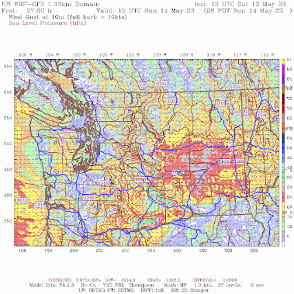
The UW WRF model is predicting very strong surface wind gusts tomorrow morning over eastern Washington, with some winds hitting 40 mph (see below). There will be blowing dust.

To get an uber heat wave around Seattle, the thermal trough of low pressure has to be right over Seattle, not to our south. This is why we won't go crazy warm tomorrow.
These easterly winds over our region will be unusually strong, as indicated by the forecast normalize anomalies from climatology tomorrow morning for wind speed around 800 meters above sea level (see below). Up to 4-5 standardized anomalies over eastern WA, which indicate a very unusual situation.

The easterly winds will enhance warming over the western slopes of the Cascades due to downslope compressional warming.
Temperatures tomorrow should be slightly warmer than today over western Washington, with highs between 84-89F away from the water around Puget Sound, and a bit warmer to the south (see forecast temperatures at 5 PM Sunday below).
.gif)
A transition to cooler temperatures will occur late Monday.
Enjoy Mother's Day and watch for dust in eastern Washington.
